Emilio Guida holds an MA in Political Science from the State University of Milan. He is the author of the book “Intelligence. Costante storica, variabile teorica e prospettive post-bipolari” published by Ledizioni in 2016.
States and private actors are increasingly investing in satellite (SAT) technology. This paper presents an analysis of the reasons underlying the diffusion and strategic value of SAT technology, particularly with regard to the importance of information and data both in international policy and the management of humanitarian crises and issues. Humanitarian emergencies are characterised by elements of uncertainty that can be mitigated through the use of objective analytical tools that have the potential to predict outcomes. The dynamics examined concern the overlapping functions of space technology (in particular, Synthetic Aperture Radar) and data processing. The intensification of investments in SAT technology is due to the reduction of costs, public–private partnerships in the management of resources and assets to tackle the various crises, and, particularly, the dual-use or civil–military framework. There also remains strong international competition in the field of space research, which drives progress in space exploration and cybenetics. The paper investigates the potential of SAT technology in humanitarian work, taking into account the risks and opportunities that coexist in every great technological innovation and shape the expectations of the various players in its development and use.
Introduction
The international system today largely consists of a fluid and fragmented reality. Both states and non-state actors interact within a complex environment of economic patterns and political actions. Transnational challenges (climate change, immigration, failed states, terrorism, proxy wars, regional instability, pandemics, territorial disputes) interlink with national ideologies and political reconfigurations. All this generates the need for new and effective tools to better understand different international political scenarios and the contexts of crises, as well as to manage humanitarian interventions as safely and effectively as possible.
States make use of the classic tools of foreign policy (such as intelligence and diplomacy) for the difficult operation of taking a position in the structure of power in specific geographic areas in which we can observe the presence of non-state actors, the privatisation of power and security operators, asymmetric conflicts, and denial and deception regarding everything concerning state power. This is the context in which large humanitarian operations (often accompanied by military interventions) are implemented in the name of ‘protection’. Humanitarian negotiations and the use of diplomatic tools occur in a space of ongoing competition among various kinds of interests (state, corporate, etc.), with incessant attempts by actors to exploit information and data to favour their own positions.[1] This is the geo-informative power that stimulates and justifies the actions of various stakeholders involved in humanitarian emergencies and protracted crises, and it creates the need to map and monitor territories, flows of people, environmental changes and so on.
In humanitarian contexts, satellite (SAT) technology has become highly relevant, thanks in particular to Synthetic Aperture Radar (SAR) technology[2] and interferometric tools.[3] These elements allow both predictive and dynamic analyses.
As in the Mars and moon missions, we can observe a competence overlap of space and cyberspace technology, such as in the search of water under the soil on Mars.[4] These operations involve SAT technology as well as radar and data elaboration used in the main satellite-based remote sensing activity based on earth. In general, SAT technology allows us to effectively monitor conflict areas, watch the real consequences of climate change and manage rescue missions in emergency areas.
A different point of view
Satellites are increasingly used to observe and analyse events from a privileged point of view. Different vantage points often give rise to new perspectives, especially in geopolitics.
The use of radar and optical satellites has become the best practice not only for the safe collection of information, but also for achieving a better situational awareness for analysis and research into climate change, the political instability of territories, the post-disaster humanitarian aid management and other global issues. SAT technology allows actors to evaluate concrete facts in crises through the careful observation of satellite data. All of this is possible thanks to the nature of satellites, which are removed from everyone and everything, but also able to see everything (even at night or in cloudy weather) based on chemical and physical characteristics. The data can be manipulated (or misinterpreted) for various reasons – sometimes political – however, they maintain the basic objectivity necessary for studies and analyses of various kinds, in particular those linked to a territory and its physicality (types of soil, presence of water, verification of water flows, lava flows, infrastructure, etc.).
In general, satellite imagery is suitable for use in humanitarian contexts and complex emergencies that are increasingly difficult to fully understand, partly due to the circulation of conflicting information produced by different actors (intelligence agencies, armed groups, non-governmental organisations or NGOs, etc.). The ‘chaos’ generated raises serious issues about the modalities of data collection and use in parallel with the circulation of unverified and redundant information. All this often works to the advantage of certain elite groups, to the detriment of most others.
As is well known, predictive analysis – particularly active in the commercial, academic and security fields – needs two fundamental elements: an adaptive analytical model for the algorithm and a huge flow of data.[5] It is understandable that the precious data (and the result of its elaboration) from satellites can exponentially increase the ability to predict structural phenomena observable in time and space. In the humanitarian context, SAT is valuable for predictive modeling/forecasting of future scenarios but also for retrieving information on and assessing past and present developments (e.g. land use/land cover changes).
Initially used in commerce (in 2004, Walmart used a big data solution for the first time to figure out in advance what products customers will buy in the face of certain events, such as hurricanes),[6] predictive analytics has since been adopted for security (law enforcement and intelligence). Although it is clearly not possible to predict the future in general,[7] the analysis of a large amount of data processed through certain methods (deductive, inductive or mixed) allows the prediction of various behaviours that are repeated over time in what are called series or events, which can be associated with hot spot analysis (data analysis through geolocation) and timing analysis. In the field of security, data is already being used to predict crimes.[8] Using factors such as habit, social position, primary needs, climate and quantity of resources, predictive analyses are also possible in humanitarian intervention contexts and to ensure better resource management. Predictive analyses have limits on the imponderables, but are able to work in contexts that are structured or limited by issues related to people’s needs (water, food, safety, etc.). Predictivity is not the product of data, but largely of the logical reasoning that underlies the algorithms. It is something only experts in the field are able to identify.
In fact, today there is fierce competition in the field of space assets and computing capacity (including using quantum computers). This competition is mainly because of the potential data holds for:
- Predictive analysis in the fields of commerce, academics and national security
- Collection of strategic information (military and intelligence)
- Address global challenges, such as climate change, using collected data
- Management of critical events and resilience assessments
- Programming and monitoring of anthropic activities (agriculture, construction, etc.)
- Gaining a broad, dynamic, proportionate and detailed view of situations (contextual knowledge supremacy).
The last point is linked closely to network-centric warfare,[9] involving a systemic approach born of the hard sciences merged with political science and international relations.
Crisis and SAT
Many humanitarian contexts are characterised by complex, uncertain and unstable operational frameworks, regardless of the presence or absence of war scenarios. Indeed, ‘crises are more common than the actual outbreak of war’.[10] Methods of waging war have changed,[11] becoming difficult to clearly identify, but peacetime too is marred by continuous cycles of crises of various kinds.
Several scholars have observed that we live in a state of permanent crisis. A crisis should, by definition, not be a long-lasting condition. A permanent crisis is an oxymoron. However, since the 1990s, we have been experiencing a continuous narrative of crisis, and governments and social organisations have been acting accordingly.[12] Financial crises, debt crises, migration crises, the crisis of terrorism in the West, the climate crisis, the pandemic – crises have proliferated in parallel with the expansion of humanitarian approaches to other spheres of governance.[13]
Looking at the effects of these crisis narratives, one can easily observe the capacity to channel enormous resources (economic, human and scientific) to certain sectors. Crises can create a specific order through the state of exception.[14]
The state of exception, based on the ability of states to transcend the rule of law in the name of the public good, benefits from its own conception of security, terrorism, immigration and financial crisis. Data can be used to mislead people and create a sense of crisis.
The narrative of crisis strongly affects people’s everyday lives, amplifying the facts and consequently distorting reactions to issues such as, for example, migration.[15] This is possible because a crisis puts into play (and also endangers) gains such as economic well-being, social position, safety, history and culture, individuals’ health, public health and sovereignty.
Against this backdrop of ongoing crises, SAT data can play an important role in the articulation of contingent humanitarian objectives.[16] However, the use of new technologies and digital humanitarianism remain controversial. On the one hand, new technologies make it possible to inform as many people as possible in real-time. The information may include maps, warnings of additional hazards, good health practices or details on the organisation of aid.[17] On the other hand, it is necessary to remember that there are objective and cultural limits to the use, for example, of smartphones (primarily poverty and education).[18]
The mass collection of data in advance, during and after crises can be an excellent method of increasing the analytical capacity in the case of humanitarian action; however, actual data processing capacity problems remain. There are also ethical issues concerning privacy. Currently, there are no regulations on data use in humanitarian contexts, but the European GDPR is considered the reference model.[19] Recently in Afghanistan, for example, data collected by humanitarian organisations was left behind in the chaotic evacuation due to the Taliban takeover. This increases the risk of misuse of data and digital devices.[20]
Improving access to SAT
States and transnational corporations are investing in SAT technology. As a result of large investments, a considerable reduction has been achieved in launch costs. This was possible partly because of the osmosis between science and politics at the international level (projects sponsored by European Space Agency – ESA – or the wider International Institute for Strategic Studies), but to a great extent because of the strong participation of SpaceX and Blu Origin alongside NASA, the United Launch Alliance and Boeing.
The reduction in development costs and time also applies to the satellites themselves, in particular for the mini-satellites or CubeSats of 1 litre that can be launched in a group with a single carrier to create an effective constellation to monitor and analyse a given territory with a frequency of up to a few hours.
Thus, satellite systems are no longer exclusively state resources. In fact, today’s technology has allowed the low-cost construction of mini-satellites (100–300 kg) and micro-satellites (10 –100 kg) suitable for constellations of Optical and Radar SAR space-based sensors, which can make all the difference in the collection and analysis of vital information, increasing strategic effectiveness at a low budget.
Commercial small SAT constellations for earth observation are now emerging, providing paid observation services (optical and radar). The new space companies develop their own small satellites, which have limited performance but can more frequently revisit and observe targets on demand, and sell the data gleaned from them.
This is a gradual and scheduled spin-off working process, entailing a shift from state (military and national security) technology to space technology mini-assets.
At present, at least ten actors are working to transfer SAR technology, with the process of spinning off technology for commercial use lasting five years. The time required does not depend only on the planning of the release of new technologies in the commercial world, but also on technical difficulties of implementation.[21] SAR technology has been found to have a reduced spin-off time. An example is the Californian start-up Capella.[22]
The same is the case with another pillar satellite technology, satellite IoT (Internet of Things). These are spatial assets capable of identifying any traceable object in any place on earth. In space technology, a year is a very short time, but can also be full of breakthroughs. Therefore, SAR technology and SAT IoT are very close to being the next big opportunity.
Democratisation?
The reduction of costs and the entry of new players in the SAT and remote-sensing market may indicate democratisation of data access, in particular when it comes to academic and research use in sectors that study new solutions to global environmental threats (natural, climatic and linked to anthropic activity in general) or that are developing increasingly precise and refined monitoring activities.
The agenda for the United Nations’ Sustainable Development Goals includes earth observation and geolocation, key elements in the cooperation of over 190 countries to support activities in many different market application domains like transport, agriculture, construction and infrastructure monitoring.[23]
The results obtained in the management of humanitarian emergency plans following natural hazards are very positive. As we will see below, it is possible to predict how a lava flow or a flood will evolve, which areas will remain safe and where the affected population should be directed to take shelter.
SAR technology also makes it possible to achieve significant water savings by collecting data on the subsidence of cultivated land and monitoring the cultures of a territory. Similarly positive results have been recorded in planning and monitoring the reconstruction of a city or critical infrastructure.
However, this sort of openness and availability of data is limited. The first issue is the time gap that must exist between military and commercial or dual-use technologies – a delay of five to ten years, depending on the type of technology.
This gap is part of the defence strategies of those with advanced knowledge and technology. Each state slows down the spin-off in order to avoid letting other players in the international arena take any advantage.
Controlling technology spin-offs has implications for action in humanitarian contexts. The limited accessibility of technologies prevents timely actions and also lowers their effectiveness – for example, there is technology that identifies traces of human trafficking in the desert or at the sea, where satellite measurements reveal whether the boats are loaded or not based on how much of the vessel is above water. Technology exists but is often unavailable.
The different levels of technology make information sharing inappropriate, as it would reveal capabilities that must always be kept secret in an internationally competitive environment. This is especially true of humanitarian interventions, or rather interventions in the name of humanitarianism in areas of conflict or geostrategic interest.
These same factors also make academic research activity less efficient, along with the general management of humanitarian interventions such as the effective identification of humanitarian corridors, human trafficking, or safer spaces to temporarily locate displaced persons and disaster survivors.
These inter-state mechanisms are mitigated by institutional cooperation to collect local data sets and to share them with commercial entities, as in the projects by the Centre for Research on the Epidemiology of Disaster, International Cooperation for Animal Research Using Space,[24] and MOVEBANK,[25] as well as those sponsored by the United Nations Operational Satellite Applications Programme (UNOSAT).
In general, it is impossible to maintain a monopoly over military, economic and technological capabilities in the long term, as it is inevitable that over time they will become available to the peripheral states.[26] Once the new technology has been acquired, the peripheral states themselves will try to exploit it. In the context of international competition, the technology gap is used to slow down this process. It follows that only by maintaining the monopoly over technology for as long as possible is it possible to obtain the largest economic and consequently military advantage.[27]
Other limits on the use of satellites concern the data collection in particular hotspots, such as regions affected by conflict where military authorities are in control (e.g. in the Middle East, North Korea, Horn of Africa, etc.), or areas of probable extraction of natural resources.
In evaluating the positive or negative aspects of the democratisation of SAT technology, it is possible to make a final, broader argument. The greater availability of data on human activities in general, due to a greater presence of satellites, can be beneficial for everyone. However, it predominantly benefits those who monopolise computing capacity. In fact, only a few players in the world are able to work with and analyse huge amounts of unstructured data. The processing and data-fusion activities allow a few states to have very high predictive and control capabilities, transforming the spin-off of SAT technology into a trojan horse for the democratisation of data.[28]
Applications
A considerable number of space systems are today in orbit and data from them can be used for humanitarian operations, applications and needs.
In particular, satellite images are used to conduct rescue operations after earthquakes or volcanic eruptions. They help assess the damage to structures and the population using very high resolution (VHR) optical images or interferometric calculations of SAR images and allow for better rescue management by identifying escape routes and rescue corridors. Finally, they help to monitor reconstruction work.
The images are also used to identify in advance the areas at risk of floods or volcanic eruptions. During the lava flows, the processing of the various satellite images allows us to predict which areas will be affected. Satellite data is also useful for disaster mitigation in small regions through the dissemination of knowledge of which areas are at risk and of what repairs, adaptation or fortification are required for the infrastructure there.
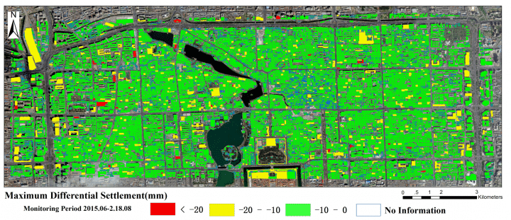
Figure 1: COSMO-SkyMed PSP InSAR mean velocity measurements in an area of Beijing. Change Detection with Interferometric image SAR (IN-SAR). Stability conditions of buildings. Source: Mao Zhu et al., ‘Detection of Building and Infrastructure Instabilities by Automatic Spatiotemporal Analysis of Satellite SAR Interferometry Measurements’, Remote Sensing, 10, no. 11 (2018), https://doi.org/10.3390/rs10111816.
Satellite monitoring allows the estimation of the probability of droughts and famines by calculating variables such as the estimate of yields, temperature, humidity, atmospheric pressure, the amount of rain in certain areas or other factors. For example, identifying anomalous sea-surface temperatures of the El Niño-Southern Oscillations, which influence seasonal precipitation levels across the tropics and subtropics, is very useful as part of the observation of the key factors impending drought.[29]
The images are also used to update the topographic maps of developing countries, which is particularly useful in the management of pandemics, such as in Guinea where the NGO Doctors Without Borders mapped over 90,000 buildings that were not on the local maps in their fight against Ebola.[30]
Satellite images have also been used to monitor fires from above, both to estimate fire intensity and to track the extent of large-scale fires. In particular, the images were used for the early identification of fires in remote areas that had the potential to grow and endanger inhabited areas.
Satellites are also a useful tool to identify conflict areas and human rights abuses by recording the number of structures destroyed, the presence of fires (fire is used as a weapon in some conflicts to destroy villages and crops), prison camps and mass graves.
According to the Union Of Concerned Scientists, about 2,000 satellites are now in operation around the earth, of which 365 are equipped with optical sensors, forty-six are equipped with radar (microwaves) sensors and 750 are devoted to telecommunications. The remaining satellites are meant for applications such as GPS, GNSS and other purposes.
Earth observation satellites provide a huge amount of data each day, which when properly processed, can yield precious information that can be leveraged using emerging artificial intelligence (AI) technologies.
There are two types of earth observation satellites: optical and radar. The data gathered by the two are complementary. The optical (panchromatic, multispectral or hyperspectral space-borne imaging, capturing visible RGB, near and far infrared, multi- or hyperspectral images)[31] provides information using consolidated processing techniques. However, observation is limited by the presence of clouds, darkness and the level of solar illumination. Radar measurement (space-borne SAR), however, can observe the earth even in presence of clouds and in darkness. Furthermore, depending on the microwave frequency, it can even provide information on targets that are covered by vegetation or even underground.
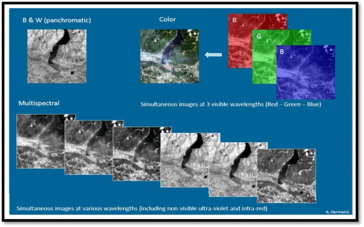
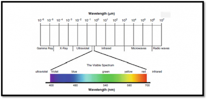
Figure 2: Subdivision of the electromagnetic spectrum into the various radiation classes. Source: G. P. Obi Reddy and S. K. Singh, Geospatial Technologies in Land Resources Mapping, Monitoring and Management, Berlin: Springer, 2018.
Resolution is the level of detail the space system is able to capture. Frequency of revisiting is how often the space system can capture observations of the same region on earth in order to monitor and detect changes and the evolution of scenarios.
SAT can further be classified based on data accessibility:
- Free data from large space systems (e.g., the ESA’s Copernicus Sentinel missions)
- Data for sale from commercial space systems (e.g., Airbus, e-Geos, Maxar, Black Sky, Planet Labs)
- Data from dual-use space systems (e.g., COSMO-SkyMed)
The European Copernicus large satellite missions provide global monitoring with both SAR (Sentinel 1, C-band, radiometric) and optical (Sentinel-2 and Sentinel-3) imaging. New planned Copernicus missions include ROSE-L for L-band SAR and infrared imaging.[32]
Another large satellite constellation for earth observation is Canada’s radar SAT mission.[33]
Remote-sensing data processing, platform and actors
The above space assets provide the necessary remote sensing measurements to be processed by algorithms on data platforms to extract the necessary information relevant to the various applications in humanitarian contexts. Several providers of these functions are institutional and private actors.
Some of the main institutional satellite remote sensing providers are:
- The Copernicus Emergency Management Service (EMS), an institutional European Commission structure within the framework of the Copernicus programme, uses Copernicus constellation satellite imagery and other geospatial data to provide free mapping services during natural disasters, human-made emergencies and humanitarian crises throughout the world. The EMS provides two main on-demand services: Rapid Mapping and Risk and Recovery Mapping.[34]
- The EMS’s users are regional, national, European and international actors in crisis management within the EU Member States; the participating states in the European Civil Protection Mechanism; the Commission’s Directorates-General and EU agencies; the European External Action Service; and international humanitarian aid organisations.
- UNOSAT, depending on the United Nations Institute for Training and Research, has been operational since 2003. Using data from Copernicus and other commercial constellations, UNOSAT Rapid Mapping provides satellite image analysis during humanitarian emergencies, both natural disasters and human conflicts. Available 24/7, year-round to process requests, a team of experienced analysts ensure timely delivery of maps, reports and data derived from satellite imagery, ready for direct inclusion in geographic information systems according to needs. UNOSAT Rapid Mapping is activated to deal with events such as floods, earthquakes, storms, landslides, volcanoes, oil spills, chemical waste spills, mapping refugee and internally displaced person (IDP) camps, conflict damage assessment, and situation analysis.[35] UNOSAT’s users are UN sister agencies and humanitarian organisations operating in line with UN policies.
Commercial satellite remote-sensing data and information providers manage their own space assets to provide services related to public safety and emergency response and management.
The EU-based e-Geos, formed in 2000 by the Italian Space Agency, is the commercial reseller of COSMO-SkyMed SAR constellation. Airbus Intelligence, also in the EU, manages the TanDEM-X SAR system and Pleiades optical high-resolution constellations. In the United States, Maxar manages the Legion optical satellite constellation, which has high- and very high-resolution capabilities.
Emerging small-vertical companies are offering new services on the market, such as Planet Labs with its own CubeSat and SkySat medium-resolution, high-revisit constellation.
The main functions of satellites in the humanitarian context are summarised in the following sections.
Coordination of Aid Action – Crisis Management and Prevention
Copernicus Service in Support to EU External Action (SEA) is a European geospatial intelligence service that analyses satellite imagery, mostly from Copernicus, and provides products such as the Activity Report, Support to Evacuation Plan and Road Network Status Assessment, as well as Camp Analysis, Critical Infrastructure Analysis, Non-EU Border Map, Conflict Damage Assessment and Crisis Situation Picture.
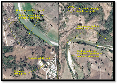
Figure 3: Sample satellite-based images for Copernicus SEA Activity Reports. Source of images: Copernicus Service in Support to EU External Action, https://sea.security.copernicus.eu.
SAR instruments operating in the X-band (used for high resolution SAR), such as COSMO-SkyMed, have demonstrated their utility in several operations to support emergency management applications. Flood mapping in open areas is probably the most widespread field of application, considering the frequency of floods worldwide and SAR’s high suitability for it. Additionally, interferometry and coherence-based change-detection techniques are useful in mapping damage by earthquakes and hurricanes as well as in monitoring the evolution of informal human settlements (e.g. IDP camps) during humanitarian crises.
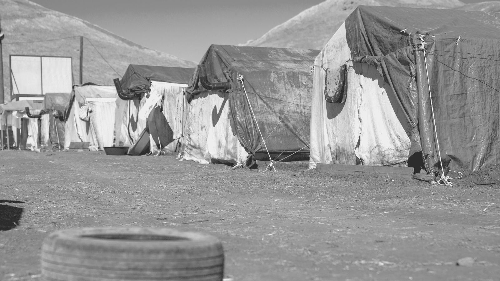
SAR interferometric products can support damage assessment activities. These products are mainly used for change detection and thematic mapping analysis, as their main capability is to highlight areas where coherence is high (e.g., human infrastructure that has not changed, such as buildings, roads, etc.) as well as areas where changes have taken place (e.g., damaged buildings, new tent camps).[36]
Movement of things or humans by sea and by land
Space-borne SAR sensing allows the remote sensing of areas of interest in all weather conditions, night or day, which is extremely important for emergency management where very quick coverage independent of weather conditions is essential (e.g. during storm or floods events).
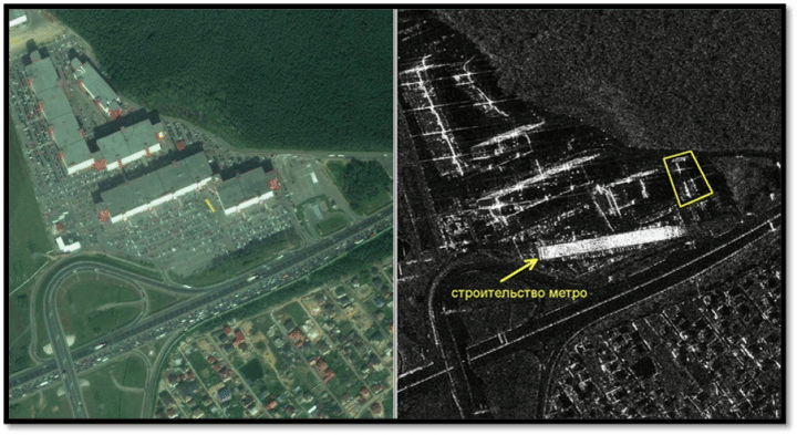
Figure 4: Left: GeoEye optical picture. © 2011 DigitalGlobe Inc., @ 1m res. Official distribution- ScanEx RDC. Right: Radar picture from COSMO-SkyMed. © ASI, 2014. New buildings that had not yet been built in 2011 are outlined in yellow. Source: Geo for All, ‘COSMO-SkyMed inizia a diffondere immagini radar attraverso ScanEX in Russia’, 3 February 2014, www.geoforall.it/k4c3p.
It has also been used in a research project to assess the feasibility of a system to monitor immigration flows across the Mediterranean Sea solely relying on images from scientific and commercial satellites already in regular operation. The project – Space Shepherd by Polytechnic University of Milan – can automatically detect vessels using both optical and SAR images, and has the ultimate goal of integrating information from a number of satellites to:
- remotely monitor the Southern Mediterranean Sea
- detect the presence of possible vessels
- identify migrant vessels and keep the relevant authorities informed
- track the vessels and issue warnings in case of danger
- support search and rescue operations.
Maritime activities make up a large portion of human commercial trade, accounting for 90% of goods traded and 12% of global GDP in 2019. Every day, ships of different types, sizes and origins cross the world’s seas. Some are used not only for commerce and transport, but also for illegal activities. In addition to conventional positioning and tracking systems, detection by earth observation satellites is an effective means to monitor human movement across the seas. Copernicus is working towards this goal by conducting border and maritime surveillance to detect illegal flows of people, weapons and drugs.
Frontex, for example, currently delivers eleven products as part of Copernicus: Coastal Monitoring, Pre-frontier Monitoring, Reference Imagery and Mapping, Maritime Surveillance of an Area of Interest (satellite imagery), Vessel Detection Service, Vessel Tracking and Reporting Service, Vessel Anomaly Detection Service, Environmental Assessment, Large Area Pre-frontier Monitoring, ProDetect Service, and MUSO Migration Analytical Assessment.[37]
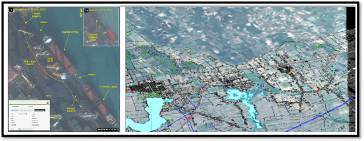
Figure 5: Left: Coastal monitoring service. Right: Reference mapping. As a Copernicus entrusted entity, Frontex is responsible for the border surveillance component of the Copernicus Security Service. Credit: Frontex.
Risk assessment and predictive analysis of floods and volcanic eruptions
As space-based earth observations are delivering a growing amount and variety of data, the potential of this information to better support disaster risk management is coming under increased scrutiny. Disaster risk management actions are commonly divided into the various steps of the disaster management cycle: prevention to minimise future losses; preparedness and crisis management, often focused on saving lives; and post-crisis management aimed at re-establishing services supporting human activity.[38]
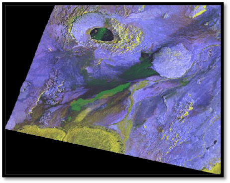
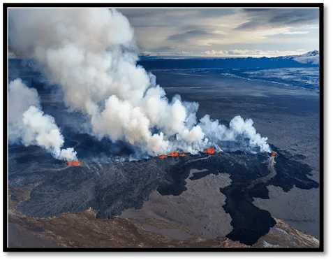
Figure 6: Left: Composite of three images acquired on 17 July, 2 August and 3 September 2014 in StripMap HIMAGE mode, polarisation HH, of the Bardarbunga volcano, Iceland. Right Descending. COSMO-SkyMed, © ASI, distributed and processed by e-Geos. Right: Photo of the Bardarbunga volcano, Iceland. RTH Sigurdsson/Arctic Images/Discover the World. Source: Will Coldwell, ‘Bardarbunga Volcano Erupts in Iceland: Spectacular Photos Taken from the Sky’, The Guardian, 4 September 2014, https://www.theguardian.com/travel/2014/sep/04/-sp-bardarbunga-volcano-erupts-iceland-spectacular-photos.
Volcanic eruptions differ from other natural disasters in that they are located in fixed areas of the earth. Remote sensing has become a popular tool for observing the numerous active volcanoes in the world. Volcanic processes can occur far below the earth’s surface, invisible to the naked eye. Among the various remote-sensing techniques, SAR satellites provide a powerful tool to help study and understand the structure of a volcano and its destructive capacity.
In relation to volcanic eruptions, radar interferometry is used for two main purposes: examining the topography of a volcano and mapping surface changes such as lava flows or deformations. Using this data and a precise analysis of the event, it is possible to anticipate the spread of lava tongues and prepare precise evacuation plans. This is possible, for example, using satellites such as COSMO-SkyMed.
SAR acquisitions make it ideal for measuring fast-changing ground deformations, allowing scientists to detect the complex dynamics of volcanoes and facilitate the identification of precursors to potentially disastrous eruptions.[39]
Assessments of the quality of land
The analysis of satellite images is particularly useful for sustainable agricultural development of disadvantaged areas that are often affected by famine or adverse climatic events.
SAT images processed to reveal the chemical and physical characteristics of the soil and the surrounding environment allows the optimisation of the use of water and fertilisers, as well as monitoring of crop progress by measuring the height and consistency of plants.
The OpenSurface Project is an AI platform that helps governments, companies and researchers track, monitor land-use changes as well as aggregate data from diverse sources to monitor (and even forecast) deforestation and subcanopy changes, evaluating present and future biodiversity levels. The information comes from the satellite as well as audio sensors and smoke detectors positioned in the monitored areas. OpenSurface is currently used for deforestation control in Chile.[40]
SAR technology is particularly useful for land value estimates, water needs estimates (through subsidence measurement), and crop monitoring and forecasting.
For example, it is known that rice is India’s most important food crop. The majority of rice is sown in the kharif season in the country. This is the monsoon, when cloud cover poses a major problem for optical remote sensing. Therefore, since 1998, rice acreage in India has been estimated using SAR data, thanks to technology that uses its own source of illumination, can operate both at day and night, and can penetrate through clouds.
As it uses the microwave portion of the electromagnetic spectrum, SAR data is ideal for discriminating among different vegetation types as the scattering at these longer wavelengths is driven by crop-specific, larger-scale structures (size, shape and orientation of leaves, stems and fruit) as well as by the volume of water in the vegetation canopy at the molecule level.
SAR-based pre-harvest rice-area monitoring can help make decisions related to food crop management and procurement, and to support food security programmes.[41] Figure 7 has images based on qualitative criteria on agriculture.
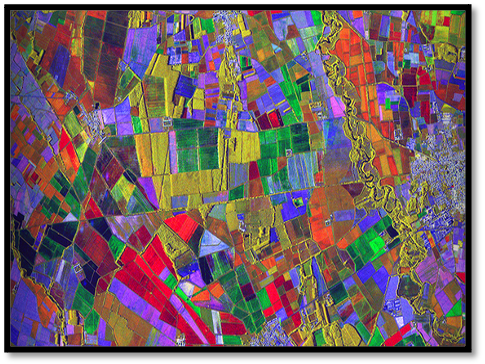
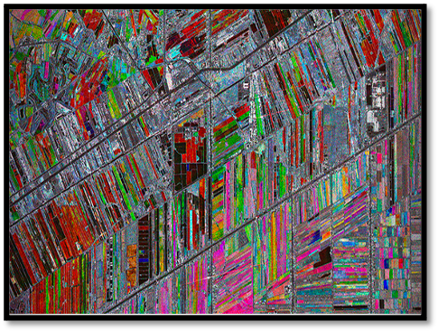
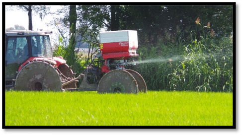
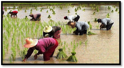
Figure 7: Left top: Agricultural fields in Lombardy, Italy. RADAR SAR COSMO-SkyMed, © ASI (http://share.egeos-services.it/gallery.html). Right top: Rice fields in Thailand. COSMO-SkyMed. © ASI; Left bottom: Use of precision fertilisation. Right bottom: Rice cultivation in Thailand.
It is important to note that all these functions are possible because of the integration of space-borne SAR sensing with space-borne optical sensing in all weather and light conditions. Elaboration and data fusion can increase analytical capacity tenfold.
Conclusion
In an increasingly complex world characterised by the persistent presence of crisis dynamics of various kinds, which have the power to aggregate resources as well as real or virtual human activity, it is necessary to adopt tools that can register and analyse as many data points as possible.
The acceleration of states competition, together with the direct involvement of the private sector – which uses technology spin-offs controlled by the time gap – has led to wider availability of SAR and optical SAT technology.
This new opportunity is positive as it allows the collection of an enormous amount of data that is useful in the search for solutions to humanitarian crises, offering new perspectives for analysing events as they happen, such as in human geography.[42] Actually, more satellites from various actors means more information and different applications especially for NGOs or international organizations engaged in development and support activities in areas facing humanitarian crises.
The opportunities for greater use of satellites in humanitarian contexts are manifold, from the more precise and timely understanding and assessment of crisis scenarios where rapid interventions are needed, to monitoring the reconstruction and adaptation of environments after disasters. But even before a crisis, the enormous amount of information allows populations to increase resilience and to develop a greater awareness of the main problems in the territory through best practices.
The development of new dedicated satellites, used by transnational government groups, can be considered an element that leads to the democratisation of the use of satellite images and their processing. However, for purely military and security reasons, states (the true leaders of the most technological advances) control the technological spill-overs that could help humanitarian actors. Thus, an increase in available information does not always correspond to an improvement in democracy or equality.
However, new technologies are pushing to increase capacity to collect ever more refined, precise and invasive data on human activity. More and more information is expected to be collected and transmitted by satellites. The variety of uses of satellite images for humanitarian purposes is increasingly evident. They no longer exclusively concern images, but – by aggregating the visual data with chemical and physical data on the target, soil, water and atmosphere – also help in the management of pandemics, holding oil, fracking and fishing companies to account, identifying the emission of pollutants and use of water, and forecasting soil conditions due to climate change.
Even though states gradually release the technology for use in civilian contexts, the use of SAT technology (demonstrated by the diffusion of projects capable of sharing information) remains a fundamental element to improve the effectiveness, timeliness and safety of humanitarian interventions in crisis areas.
Ultimately, it is a resource capable of providing clarity despite looking from afar.
The author acknowledges the support of the project “Humanitarian Diplomacy: Assessing Policies, Practices and Impact of New Forms of Humanitarian Action and Foreign Policy” funded by the Research Council of Norway and led by Antonio De Lauri at the Chr. Michelsen Institute.
Footnotes
[1] Antonio De Lauri, ‘Humanitarian Diplomacy: A New Research Agenda’, CMI Brief, 2018.
[2] SAR here refers not to the classic optical technology but to radar measurement and imaging reconstruction technology.
[3] Infometric SAR (InSAR) uses two or more SAR images, and is used for measuring land surface altitude and surface movements, among other things.
[4] In 2018, the Mars Advanced Radar for Subsurface and Ionosphere Sounding discovered liquid water 1.5 km under the surface of Mars. The instrument that revealed the presence of water was a radar that transmitted at a very low frequency (between 1.8 and 5.0 MHz). Lower-frequency radio waves are better able to pass through matter, at the expense of image quality. The technique is the same that was used to observe the underground lakes of Antarctica. An antenna of over 20 m in length was used. Processing the data on the salt-water characteristics completed the work of identifying the subterranean lake system of Mars. See Sebastian Emanuel Lauro et al., ‘Multiple Subglacial Water Bodies Below the South Pole of Mars Unveiled by New MARSIS Data’, Nature Astronomy, Vol. 5, 2021.
[5] Walter L. Perry et al., Predictive Policing: The Role of Crime Forecasting in Law Enforcement Operations, Santa Monica CA: Rand Institute, 2013.
[6] Viktor Mayer-Schönberger and Kenneth Cukier, Big Data: A Revolution That Will Transform How We Live, Work, and Think. Boston: Houghton Mifflin Harcourt, 2013.
[7] Karl R. Popper, The Poverty of Historicism, London: Routledge, 1961.
[8] Giovanni Mastrobuoni, ‘Crime is Terribly Revealing: Information Technology and Police Productivity’, University of Turin and University of Essex, 2019, http://www.restud.com/wp-content/uploads/2020/03/MS23656manuscript.pdf. In addition to KeyCrime, Precobs and predpol are the most important predictive policing software at present.
[9] Network-centric warfare is an approach that converts the information advantage, in part made possible by information technology, into a competitive military advantage through a solid network of computers and sensors at the disposal of geographically distributed and well-informed forces. Paul T. Mitchell, ‘Network Centric Warfare: Coalition Operations in the Age of US Military Primacy’, The Adelphi Papers, 46, no. 385 (2006): 75–89; Gary Chapman, ‘An Introduction to the Revolution in Military Affairs’, XV Amaldi Conference on Problems in Global Security, Helsinki, 2003.
[10] Richard K. Betts, ‘Surprise Despite Warning: Why Sudden Attacks Succeed’, in Christopher Andrew, Richard J. Aldrich and Wasley K. Wark (eds.), Secret Intelligence, New York: Routledge, 2009, p. 94.
[11] Murray Williamson and Knox MacGregor, The Dynamics of Military Revolution, 1300–2050, Cambridge: Cambridge University Press, 2001.
[12] Alessandro Colombo, Tempi decisivi. Natura e retorica delle crisi internazionali, Feltrinelli, Milano, 2014
[13] Antonio De Lauri, The Politics of Humanitarianism: Power, Ideology and Aid, London: I.B. Tauris, 2016.
[14] Carl Schmitt, Politische Theologie: Vier Kapitel zur Lehre von der Souveränität, Munich and Liepzig: Von Duncker and Humblot, 1922; Giorgio Agamben, Lo stato d’eccezione, Turin: Bollati-Boringhieri, 2003
[15] Antonio De Lauri, ‘A Critique of the Humanitarian (B)order of Things’, Journal of Identity and Migration Studies, 13, no. 2 (2019): 148–66.
[16] Katie Cashman, ‘UNOSAT: Using Satellites to Map the Future of Humanitarian Aid’, Reset Digital for Good, 30 November 2020, https://en.reset.org/blog/unosat-using-satellites-map-future-humanitarian-aid-11302020.
[17] OCHOA, Humanitarianism in the network age, Ochoa policy and studies series, UN Office, 2013, https://www.unocha.org/sites/unocha/files/HINA_0.pdf
[18] Róisín Read, Bertrand Taithe and Roger Mac Ginty, ‘Data Hubris? Humanitarian Information Systems and the Mirage of Technology’, Third World Quarterly, 37, no. 8 (2016):1314–31, https://www.humanitarianresponse.info/sites/www.humanitarianresponse.info/files/documents/files/data_hubris_humanitarian_information_systems_and_the_mirage_of_technology.pdf.
[19] European Parliamentary Research Service, ‘Technological innovation for humanitarian aid and assistance’, Scientific Foresight Unit, Brussels: European Union, 2019, pp. 37–8, https://www.europarl.europa.eu/RegData/etudes/STUD/2019/634411/EPRS_STU(2019)634411_EN.pdf.
[20] Paradoxes of Protection: The Afghan Case, https://www.humanitarianstudies.no/events/paradoxes-of-protection-the-afghan-case/
[21] For SAR technology see Preeti Wadhwani and Prasenjit Saha, ‘Synthetic Aperture Radar Market’, Global Market Insights, December 2020, https://www.gminsights.com/methodology/detail/sybthetic-aperture-in-space-sector-market.
[22] See https://www.capellaspace.com.
[23] United Nations Office For Outer Space Affairs, ‘European Global Navigation Satellite System and Copernicus: Supporting the Sustainable Development Goals’, Vienna: United Nations, 2018, https://www.unoosa.org/res/oosadoc/data/documents/2018/stspace/stspace71_0_html/st_space_71E.pdf.
[24] Leonie Asendorpf, ‘ICARUS: Behavioural Observation of Animals using Mini-Transmitters and Satellites’, Reset Digital for Good, 5 August 2020, https://en.reset.org/blog/icarus-behavioural-observation-animals-using-mini-transmitters-and-satellites-08052020.
[25] The database is financed by the Max Planck Society and the University of Constance. The development was also supported by the National Science Foundation, the German Aerospace Center, the German Science Foundation and NASA.
[26] Robert Gilpin, War and Change in World Politics, Cambridge: Cambridge University Press, 1981.
[27] John J. Mearsheimer, The Tragedy of Great Power Politics, New York: W.W. Norton, 2014.
[28] H.B. Mitchell, Data Fusion: Concept and Ideas, Berlin: Springer, 2014; Federico Castanedo, ‘A Review of Data Fusion Techniques’, The Scientific World Journal, 2013, https://doi.org/10.1155/2013/704504; John J. Guiry, Pepijn van de Ven and John Nelson, ‘Multi-Sensor Fusion for Enhanced Contextual Awareness of Everyday Activities with Ubiquitous Devices’, Sensors, 14, no. 3 (2014): 5687–701.
[29] Committee on Earth Observation Satellites, ‘Satellite Earth Observations in Support of Disaster Risk Reduction’, European Space Agency, 2015, http://www.eohandbook.com/eohb2015/files/CEOS_EOHB_2015_WCDRR.pdf, p. 69.
[30] Remì Froment et al., ‘Use of Earth Observation Satellites to Improve Effectiveness of Humanitarian Operations’, Center for Research on the Epidemiology of Diseases, Université catholique de Louvain, 2020, p. 13.
[31] Space-borne optical remote-sensing image types and quality are strongly dependent on the satellite’s on-board sensor technologies. Optical space-borne sensors can cover single or multiple regions of the optical electromagnetic spectrum, from infrared to the highest light frequencies, with different numbers of ‘channels’, resolutions and accuracies. Sensor systems can operate in the visible spectrum with bands equivalent to the three primary colors – blue (380–440 nm), green (440–600 nm) and red (600–750 nm) – the near infrared range (750–1100 nm), and the short-wave infrared range (1550–2400 nm). For further details, see: J. G. Liu, ‘Remote Sensing: Passive Sensors’, Earth Systems and Environmental Sciences, reference module, 2013, https://www.sciencedirect.com/science/article/pii/B9780124095489029560; European Space Agency, ‘The Information Contained in an Image: Analogue Versus Digital’, eduspace, 6 November 2012, https://www.esa.int/SPECIALS/Eduspace_EN/SEM4HR3Z2OF_0.html; ‘How are Satellite Images Different from Photographs?’, https://www.colby.edu/biology/BI352/Labs/satelliteim_info.pdf.
RGB refers to the red, green and blue spectral bands, each of which carries different information. The sensor can detect multiple wavelength ranges separately or simultaneously; each of them forms an image. A set of such images is called a multispectral image and each images in the set is called a band spectral.
[32] European Space Agency, ‘Copernicus Sentinel Expansion Missions’, https://www.esa.int/Applications/Observing_the_Earth/Copernicus/Copernicus_expansion_missions.
[33] Canadian Space Agency, ‘RADARSAT Constellation Mission’, https://www.asc-csa.gc.ca/eng/satellites/radarsat/default.asp.
[34] Copernicus, ‘Copernicus Emergency Management Service’, https://emergency.copernicus.eu.
[35] United Nations Institute for Training and Research, ‘United Nations Satellite Centre UNOSAT’, https://www.unitar.org/sustainable-development-goals/satellite-analysis-and-applied-research.
[36] D. Grandoni et al., ‘Space-Based Technology For Emergency Management: TheCOSMO-SkyMed Constellation Contribution’, Procedia Technology, 16 (2014): 858–66, https://emergency.copernicus.eu/mapping/sites/default/files/citations/1-s2.0-S2212017314002631-main.pdf.
[37] This is not an undisputed issue and there is the potential for misuse as satellite data might contribute to more restrictive migration policies, hindering migrant vessels to reach a safe harbour.
[38] G. Le Cozannet et al., ‘Space‑Based Earth Observations for Disaster Risk Management’, Surveys in Geophysics 41 (2020):1209–35, https://doi.org/10.1007/s10712-020-09586-5.
[39] Patrizia Sacco et al., ‘Mitigation of Volcanic Risk: the COSMO-SkyMed Contribution’, May 2015, Fringe 2015: Advances in the Science and Applications of SAR Interferometry and Sentinel-1 InSAR Workshop.
[40] Katie Cashman, ‘OpenSurface: Pioneering AI Tracks Land Use and Deforestation from Outer Space’, Reset Digital for Good, 31 March 2020, https://en.reset.org/blog/opensurface-pioneering-ai-tracks-land-use-and-deforestation-outer-space-03312020.
[41] Varunika Jain et al., ‘Rice (Kharif) Production Estimation Using SAR Data of Different Satellites and Yield Models: A Comparative Analysis of the Estimates Generated Under Fasal Project”, International Archives of the Photogrammetry, Remote Sensing and Spatial Information Sciences, vol. XLII-3/W6 (2019): 99–107, https://doi.org/10.5194/isprs-archives-XLII-3-W6-99-2019.
[42] Human geography concerns the mapping of people, groups, organizations, sentiments and attitudes, norms, belief systems, social activities, and ‘ways of doing business’ over space and time. See Andrew Jones, Human Geography: The basics, London: Routledge, 2012. For evolution in geospatial intelligence, see Robert M. Clark, Geospatial Intelligence: Origins and Evolution, Washington, DC: Georgetown University Press, 2020.